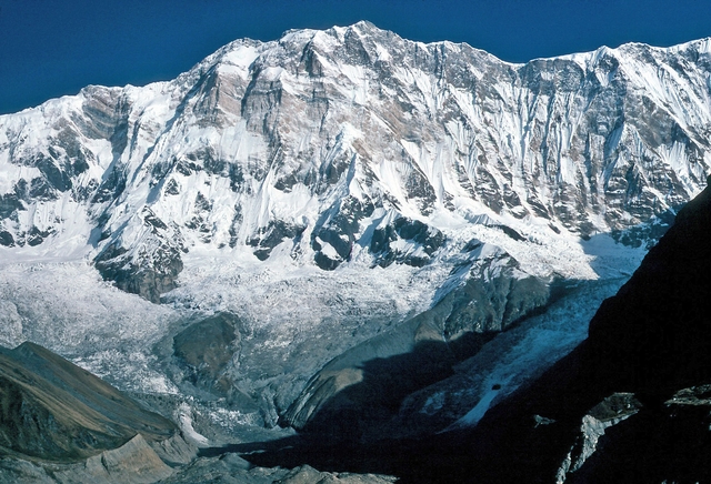
Ortler
Southern Rhaetian Alps, South Tyrol, Italy
Oxygen Analysis — Oximeter
Oxygen comparison
Required Preparation
At 3905 m, with 62% oxygen available, perceived effort increases compared to sea level.
How to prepare
- Occasional training: specific preparation and progressive acclimatization are required before the summit.
- Regular training: plan acclimatization stops and monitor oxygen saturation.
- Endurance training: respect physiological adaptation times even if fitness level is high.
- Consider a sports medical assessment before the ascent.
Route and Trail
Peak Guide
The King of South Tyrol. The highest peak in all of Tyrol and the entire Ortler-Cevedale group, a colossus of ice and metamorphic dolomite that rises majestically to 3905 meters above the basin of Sulden (Solda). Once the supreme summit of the Austro-Hungarian Empire, the Ortler remains one of the most coveted and feared mountaineering ascents in the Eastern Alps: the normal route from the Payer Hut demands absolute respect for the crevassed glacier, cool nerves on the equipped rock sections, and endurance forged for interminable hours at altitude.
Quick Facts
| Detail | Value |
|---|---|
| Altitude | 3905 m a.s.l. |
| Mountain group | Southern Rhaetian Alps, Ortler-Cevedale Group |
| Names | Ortles (IT), Ortler (DE) |
| Difficulty | PD+ (Slightly Difficult, Upper Grade) — pitches of grade II/III, ice slopes up to 40–45° |
| Total elevation gain | ~876 m (from Julius Payer Hut, 3029 m) |
| Total distance | 21.0 km round-trip (from Sulden) |
| Route development | 23.0 km (actual trail distance) |
| Ascent time | 4–5 hours from Julius Payer Hut |
| Recommended season | Mid-June – mid-September |
| Starting point | Sulden / Solda (1860 m) |
| Key intermediate hut | Julius Payer Hut (3029 m) — mandatory overnight stop |
Oxygenation and Acclimatization
At 3905 meters the Ortler grazes the four-thousand-meter threshold without granting any reprieve: barometric pressure delivers only 62% of the oxygen breathable at sea level. This value places the climb squarely in the high-altitude zone, where Acute Mountain Sickness is a concrete risk for anyone who underestimates acclimatization. Typical summit SpO₂ for an acclimatized individual ranges between 78 and 84% — values sufficient to drastically slow every movement and turn each step on the glacier into an exhausting negotiation with one's own lungs.
The night at the Julius Payer Hut (3029 m) is the first non-negotiable safeguard: those hours at three thousand meters grant the body the minimum time to initiate its compensatory ventilatory response. During the dark ascent toward the glacier, impose a severe and relentlessly slow pace: inhale through the nose for four counts, exhale through the mouth for six. On the steeper glacier slopes, adopt pressure breathing — blow firmly against nearly closed lips to maintain alveolar pressure and counteract the mounting hypoxia. If your headache becomes hammering, if confusion appears, if you lose coordination or develop a dry persistent cough, do not negotiate with pride: descend immediately and without hesitation.
Note: This advice is informational and does not replace medical consultation. Consult a physician specializing in high-altitude medicine before undertaking demanding ascents.
The Ascent (Normal Route via Payer Hut)
Day 1: From Sulden to Julius Payer Hut From Sulden / Solda (1860 m) a well-marked trail climbs determinedly up the western flank of the Ortler, threading between high-altitude pastures and boulder fields that progressively grow more severe. In three to four hours of steady walking you gain roughly 1170 meters of elevation, reaching the Julius Payer Hut (3029 m), perched on a rocky pulpit with a frontal view that pins the soul: the entire northwest face of the Ortler, a wall of ice and rock that seems endless. In the evening you prepare your gear, check crampons and harness, and attempt a short, nervous sleep before the alarm sounds in the dead of night.
Day 2: The summit push Departure in pitch darkness, headlamps slicing the black. The first section is the most treacherous from a technical standpoint: from the hut you traverse the famous Pichler Ledge (Hintere Wandl), an equipped traverse with metal chains on exposed rock that requires sure-footed movement and steady hands. Pitches reach grade II/III and rockfall is a concrete hazard, especially in the warmer hours. Once past the ledge, you step onto the lower tongue of the Ortler Glacier (Oberer Ortlerferner), where the rope team tightens and crampons begin their work.
The glacier steepens progressively, with gradients reaching 40–45 degrees on the steepest sections. Crevasses furrow the surface with regularity, and snow bridges — especially in late summer — must be probed with utmost caution. You ascend the glacial slope toward the summit ridge, where the terrain alternates between tongues of ice and rock outcrops. The final stretch to the summit (3905 m) rewards with a panorama that steals whatever breath remains: Gran Zebrù and Cevedale within arm's reach, the Brenta Dolomites on the horizon, and on the clearest days your gaze wanders as far as the Bernina and Monte Rosa.
The descent follows the same route. Pay maximum attention to the afternoon glacier: softened snow amplifies the risk of bridge collapses and slides.
Physical Preparation
The Ortler is graded PD+ but must not be underestimated: it is a complete mountaineering ascent requiring skills on rock, ice, and mixed terrain. The passage along the Pichler Ledge demands confidence in climbing on exposed, equipped terrain, while the glacier requires mastery of roped glacier travel and the ability to manage crevasses and sustained gradients under hypoxic conditions.
| Starting level | Preparation time | Key Phases |
|---|---|---|
| Expert Hiker | 3–5 months | Gain glacier experience (basic mountaineering course). At least one summit above 3500m. Familiarization with crampons, ice axe, and roped progression. |
| Average Alpinist | 4–8 weeks | Targeted outings on glacier and mixed terrain. Verify endurance on 1200m+ elevation gains at altitude. A preparatory climb such as Gran Paradiso is ideal. |
Those who have never tackled a crevassed glacier must acquire this skill before attempting the Ortler. Gran Paradiso or Cevedale represent excellent preparatory climbs to test one's altitude response and glacial progression.
Equipment
The Ortler is a mountaineering ascent on mixed terrain. Every piece of equipment serves a vital function.
Essential:
- Certified alpine helmet — rockfall on the Pichler Ledge is a real hazard
- Sharp 12-point crampons on rigid high-mountain boots
- Classic ice axe
- Harness with daisy chain, glacier rope (minimum 30m), and crevasse rescue kit
- Slings and locking carabiners for self-belaying on the chains
Recommended:
- Waterproof shell and down jacket — weather on the Ortler can turn violent without warning
- Double-layered gloves and balaclava
- Category 4 sunglasses (blinding glacier glare)
- SPF 50+ sunscreen
- Thermos with a hot drink and energy bars
- Pocket pulse oximeter to monitor SpO₂ during the ascent
Brief Historical Notes
The Ortler boasts one of the earliest first ascents in the entire Alpine arc. On September 27, 1804, at the behest of Archduke Johann of Habsburg-Lorraine, chamois hunter Josef Pichler from the Passeier Valley reached the summit together with Johann Leitner and Johann Klausner. An extraordinary feat for its era, carried out on severe glacial terrain with rudimentary equipment, predating the conquest of the Matterhorn by over half a century. The Pichler route is known today as an extremely demanding itinerary that is rarely repeated. The ledge bearing his name on today's normal route is an enduring tribute to the courage of that first step into the unknown.
The Ortler was long the highest peak of the Austro-Hungarian Empire, and during the First World War it became the theater of some of the most extreme high-altitude military operations in history, with positions and trenches carved into the ice above 3000 meters. Today the mountain is the heart of Stelvio National Park, a sanctuary of alpine nature where the summit glacier, though in retreat, continues to shape one of the most majestic landscapes in the Alps.
⚠️ Medical disclaimer: The information provided is indicative and based on general physiological data. It does not replace the advice of a physician specializing in high-altitude medicine. Consult a professional before high-altitude excursions.
Sources and References
The information on this page has been verified from the following sources
- Vie Normali — Ortles via normale
- Gulliver — Ortles via normale da Solda per il Rifugio Payer
- Aquile San Martino — Via Normale al Monte Ortles
- The Outside Planet — Via Normale Ortles
- Guide La Pietra — Ortles 3905 mt via normale
- Vie Normali — Gruppo Ortles Cevedale
- Seilschaft — Ortles 3905m
- ICAO Standard Atmosphere (Doc 7488/3)
Related peaks
Discover other peaks in the same area